The Along Track Scanning Radiometers (ATSR) are multi-channel imaging radiometers with the principal objective of providing data concerning global Sea Surface Temperature (SST) to the high levels of accuracy and stability required for monitoring and carrying out research into the behaviour of the Earth's climate. The ATSRs are designed to meet the AATSR Scientific Requirements.
History and Contributors
The ATSRs are a series of 'Announcement of Opportunity' (AO) instruments, jointly funded by the UK and Australia and flying on board the European Space Agency's ERS-1, ERS-2 and Envisat satellites. The first in the series was designated ATSR-1, the second ATSR-2 and the third in the series, the Advanced ATSR (AATSR). The ENVISAT AATSR Instrument Performance - End of Mission Report provides the definitive summary of AATSR performance.
The fourth ATSR, called the Sea and Land Surface Temperature Radiometer (SLSTR), has been funded and developed directly by ESA and is currently flown on ESA's Sentinel-3 satellite.
ATSR-1 was initially funded by the (then) Science and Engineering Research Council (SERC) and following a reorganisation of UK research organisations, by the Natural Environment Research Council (NERC), who continued and enhanced the programme with ATSR-2. The first two instruments were designed by the Rutherford Appleton Laboratory (RAL) as experimental scientific instruments. The current ATSR programme, funded by the Department Business Energy and Industrial Strategy (BEIS) was procured from Airbus and has seen the ATSR series progress to operational status. The first three ATSR instruments were also supported by the (then) Australian Space Office and the Commonwealth Scientific and Industrial Research Organisation (CSIRO). The fourth sensor, currently designated SLSTR, has full operational status within the EU's Global Monitoring for Environment and Security (Copernicus) programme.
Instrument Design
In order to measure Sea-surface Temperature from space, the two most important requisites are arguably:
- A stable and very well-calibrated radiometer must be deployed in space; and
- An effective means of determining the Atmospheric Correction must be provided.
(A)ATSR meets both of these requirements. Firstly, the radiometer has been designed to achieve exceptional precision and stability of calibration, arguably the the most rigorously designed and calibrated radiometer used in any civil space programme and, secondly, it uses a unique dual-view of the Earth's surface. This means that the Earth is viewed sequentially through two different atmospheric path-lengths. The along-track scanning geometry is shown in the figure below.
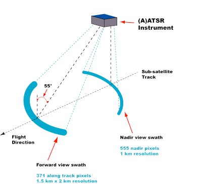
The along-track scanning geometry
Like its predecessors, AATSR is a sensitive and precise imaging radiometer with several important and innovative technological features, which lead to exceptional levels of performance.
Dual View
The required accuracies for ATSR-derived SST are better than 0.3 °C with a stability approaching 0.1 °C /decade. In order to achieve this accuracy consistently under a range of typical atmospheric conditions, ATSR views the surface at two angles, one close to the nadir (immediately below the satellite) and the other along the satellite track at close to 55° from the nadir, thereby providing two views of each point on the Earth's surface, each with a different effective atmospheric thickness. In difficult atmospheric conditions, especially in the presence of atmospheric aerosols, this enables a particularly accurate estimate to be made of the signal degradation due to atmospheric absorption and scattering.
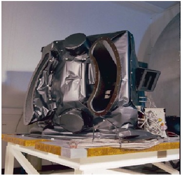
The Earth-facing side of the AATSR Flight Model. The two curved apertures can be seen, where the nadir aperture is facing out, while the larger forward-view aperture can be seen to the left of the instrument
On-board Calibration and Active Cooling
ATSR also embodies an exceptionally precise and stable on-board calibration system, comprising two reference targets specially designed for high uniformity and stability. These two targets, known as 'blackbodies' are maintained at temperatures near to the extremes of the Earth temperatures as measured by ATSR and they are both viewed during each scan cycle of the instrument. These black bodies use a design concept specially developed for ATSR-1 and are basically cylindrical cavities with nonreflecting interior coatings, good insulation and a temperature monitoring system designed for high accuracy, high precision and low drift. The targets are designed to achieve exceptional stability and uniformity and are located in a thermal environment in which they provide extremely stable radiometer reference sources.
One black body is maintained at a temperature of about 305 K, just above the maximum temperature expected to be observed over marine scenes. The other is unheated and floats at a temperature close to the ambient temperature of the instrument enclosure (~256 K), just below the expected range of marine scene temperatures. The two black bodies therefore span the full range of expected SSTs. The infrared calibration is applied automatically during the ground processing, so that users are provided with fully calibrated BTs or SSTs.
This calibration system ensures that measurements of thermal radiation from the Earth's surface are properly calibrated and do not rely on ground-based measurements, although such measurements are continually used to evaluate ATSR's performance.
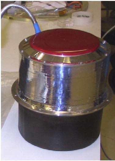
The external casing and 100mm aperture of one of the black body reference targets used by AATSR
ATSR Channels
ATSR has three channels at thermal infrared wavelengths at 3.7, 11 and 12 µm, from which surface temperatures are derived over both sea and land surfaces. A reflected infrared channel at 1.6 µm is used to improve the detection of clouds by day. In addition, from the second instrument onwards, ATSR has three more visible and near-infrared channels at 0.55, 0.67 and 0.87 µm which are used to identify cloudy areas and to measure solar radiation that is scattered and reflected from the Earth's surface and atmosphere. These channels provide measurements from which land-cover properties, for example, NDVI, as well as clouds and atmospheric particulate matter (or aerosols) can be studied. In the case of vegetation properties the along-track scanning technique is able to provide improvements in accuracy, especially in cases where the measurements are affected by the presence of excessive aerosol matter in the atmosphere.
|

